Introduction to parlitools
Evan Odell
2022-01-31
Source:../docs/vignettes/introduction.Rmd
introduction.RmdIntroduction to parlitools
parlitools is a collection of datasets, maps and data
retrieval functions for analysing UK politics.
Vignettes
In addition to this introductory vignette, there are vignettes on using
parlitools with cartogram, the British
Election Study dataset and mapping
local authorities.
Included Data
party_colours - A tibble with the ID, name and hex code
for the official colour of a variety of political parties, taken from
Wikipedia. Includes all political parties with MPs and a number without
MPs. (Sources: https://en.wikipedia.org/wiki/Wikipedia:Index_of_United_Kingdom_political_parties_meta_attributes,
mnis::ref_parties())
bes_2015 - A tibble with the British Election Study 2015
Constituency Results Version 2.2. For information on all the variables
in this dataset, see the bes-2015
vignette (Source: http://www.britishelectionstudy.com/data-object/2015-bes-constituency-results-with-census-and-candidate-data/)
leave_votes_west - The percentage of votes cast for
leave in the 2016 EU referendum. Some constituencies have actual results
and others only have estimates by Chris Hanretty; in cases where the
actual cote count is known, both the estimates and the actual results
are reported. (Sources: Hanretty, C. (2017). Areal interpolation and the
UK’s referendum on EU membership. Journal of Elections, Public
Opinion and Parties, 27(4), 466–483. https://doi.org/10.1080/17457289.2017.1287081)
Data Retrieval Functions
current_mps - Uses functions from hansard
and mnis to create a tibble with data on all current MPs,
their party affiliation and their constituency.
mps_on_date - Uses functions from hansard
and mnis to create a tibble with data on all MPs from a
given date, their party affiliation and their constituency.
Included Maps
west_hex_map - A hexagonal cartogram, stored as a simple
feature and data frame, of Westminster parliamentary constituencies.
west_hex_map can be used to create maps like this:
local_hex_map - Hexagonal cartogram, A hexagonal
cartogram, stored as a simple feature and data frame, of all Local
Authorities in England, Wales and Scotland.
Other Data Sources
There are a variety of potentially relevant data sources and datasets on UK politics, far too many for me to include them all in this package, and many of which are far too large. This list is by no means complete:
Electoral Commission - Electoral results dating back to 2005.
British Election Study - A large selection of open data, including panel surveys, linked data and aggregated Twitter data, covering elections and referenda.
hansard&mnisdata retrieval packages for parliamentary APIs.Open Council Data has data on the names, parties, and wards of all UK councillors, updated more or less weekly.
Using parlitools
Graphing Demographics and Voting Trends
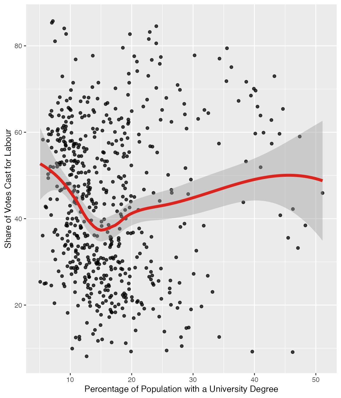
parlitools contains extensive demographic data in the
census_11 dataset. The map below shows the relationship
between votes cast for the Labour party and the percentage of the local
population holding university degrees.
library(dplyr)
library(ggplot2)

census_11 <- parlitools::census_11

bes_2017 <- parlitools::bes_2017

elect_results <- left_join(census_11, bes_2017)

degree_plot <- ggplot(elect_results, aes(y=lab_17, x=degree)) +
  geom_point(alpha=0.75) +
  geom_smooth(size=1.75, colour = "#DC241F") +
  ylab("Share of Votes Cast for Labour") +
  xlab("Percentage of Population with a University Degree")

degree_plot